The success of VPAtlas is dependent upon volunteer community scientists. You can help us field-verify potential pools that have been mapped remotely, report the location of vernal pools you already know about, or discover new-to-us pools to put on the map.
1. Understand the VP Atlas.
Watch the VP Atlas tutorial. (40 minutes)
2. Find a pool near you to visit.
Pools are not considered confirmed unless landowner permission is obtained, and your neighbors are more likely to grant you permission. Visit and explore the VPAtlas for potential and probable pools, and filter by town to see land near you.
3. Get ready to record data.
Download and print the Vernal Pool Field-Verification Data Sheet
OR
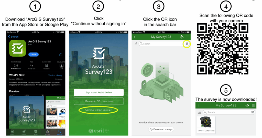
Download Survey123 to your smartphone and load the VP Atlas survey.
Make sure you understand how to properly fill out your data!
4. Get to know the vernal pool indicator species.
Vernal Pool Indicator Species I-D Sheet
Field ID Cards for Northeast Vernal Pool Indicator Species and Field ID Cards for Vermont Vernal Pool Indicator Species. Compiled by Dawn Morgan, University of Maine
Key to Amphibian eggs and larvae – This key to from Minnesota includes most species found in Vermont.
The Orienne Society’s Vernal Pool Biodiversity Workshop (video, 32 minutes)
5. Visit a pool.
For precise navigation, obtain a handheld GPS, or download a GPS app for your smartphone such as Avenza.
6. Register or log in to the VPAtlas.
Click on Add Pool Data, and fill in the data you obtained in the field.
Optional: Join the Vermont Vernal Pool Google Group.
During the spring, we encourage reports of amphibian movements from across the state to better track the phenology of breeding and road-crossing events.


